
TrueView 680/680LR, with Three Cameras for Better Range and Point Density
TrueView 680/680R
The TrueView 680/680LR is GeoCue's best 360 degree field of view system, built with the Riegl VUX-1UAV and the 680LR integrates a Riegl VUX-1LR. Select the system that best suits your projects and trust that you will achieve incredible performance in terms of accuracy and point density.
All 600-series payloads are NDAA-compliant.
PRODUCT SPECIFICATIONS
Data Collection
LIDAR + Imagery
LiDAR Scanner
(680) RIEGL VUX-1UAV-22 | (680LR) RIEGL VUX-1LR-22
LIDAR Beams/Returns
Up to 5 per outgoing pulse
Positioning and Orientation System
Applanix APX-20
Pulse Repetition Rate
(680) 800 kHz @ 120 m | (680LR) 1500 kHz@120 m
Accuracy
(680) +/-10 mm | (680LR) +/-15 mm
Precision
+/- 5 mm
Camera Sensor
3 Sony IMX-183: 1”, 20 MP, RGB -> 60 MP per payload
Mass
4.8 kg
Field of View System
360˚
WHAT'S IN THE BOX:
HARDWARE
TrueView 680/680LR 3D LiDAR Payload
ACCESSORIES/PARTS
USB Thumbdrive
GNSS Antenna
Sensor Hardcase
Accuracy Star
SOFTWARE
Includes Strip Align and Desktop Photo Add Ons
SUPPORT
1 year of hardware and software support
2 days of training included

INTEGRATIONS
LP360 Drone
Drone LiDAR and photo processing workflow made simple
Use LP360 Drone for
Intuitive workflow
Multi-flight import and processing
GIS interface allowing combination with other geospatial data
Powerful point cloud visualization with multiple and synchronized windows
LP360 Photo
We have integrated directly into our drone mapping processing software, LP360 Drone, a Photo engine to produce fast backdrop orthophotos for your LiDAR project.
LP360 Photo is the LP360 Drone add-on for Ortho mapping:
Rapidly create your orthophoto backdrop in a completely integrated workflow
Efficient fast processing leveraging the LiDAR data with the photos?
LP360 Photo additional features:
Export photo package to your 3rd party Photogrammetry software
Support most common 3rd party sensors (DJI Mavic 3E, DJI Phantom 4 RTK and DJI Zenmuse P1)
LP360 Strip Align
Data can exhibit small geometric inconsistence, especially when combining data from multiple flights. BayesMap StripAlign for LP360 Drone detects and corrects these errors via an application of sensor-specific mathematical modelling. StripAlign is a fully automated process with no need for users to set project-specific “tuning” parameters or to move in and out of the LP360 Drone processing environment – press a button and it works!
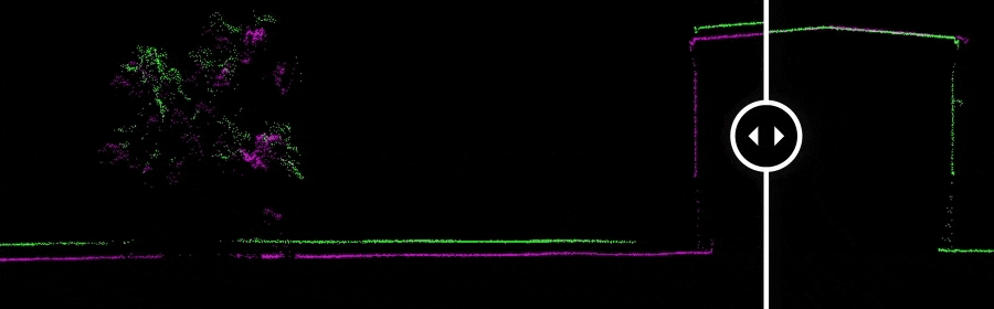
Image Exaggerated to Display StripAlign Effect
LP360 3D Accuracy
Automated horizontal and vertical checks remove the need for manual interaction
Use 3D Accuracy for:
Automatically transform your check point coordinates into you project coordinates including datum and epoch
“AutoTarget” – Automatically find a 3D target on a drone dataset
Calculation of correction for any 3D target
Seamless workflow to apply the correction on the point cloud
Use with ground control equipment
DRONE PLATFORMS
Our TrueView 3D Imaging Sensors were designed as a lightweight payload to allow flexible integrations on numerous drone platforms. We have worked with several drone providers to provide customers the complete drone mapping solution they are looking for. Don't see the company you're looking for, contact our team and we can discuss custom integrations!
